

Our first attempt at polygon mesh modeling, using point cloud methods in the field. This is a study that demonstrates the wonder of point cloud mesh models. These are accurate 3D models based on exact real world scale – data is captured in the field and used directly to create the 3D models. The technology allows for modeling as well as accurate texture mapping. The video below includes both.
The models can be brought into any 3D rendering software, measured and utilised for further purpose, including creating plans and sectional drawings of the models.
Site data gathered as such enables research, interpretation and study for later conservation, examination or even reconstruction. This is a relatively new technology area as used in heritage.
Camera Animation of the model with texture maps:
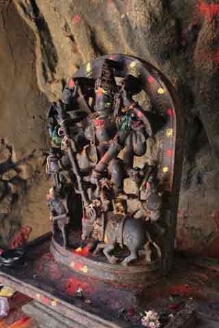
The example of our first study is a site in a remote cave in North Karnataka, India. Below are the actual photographs of the idol of Mahishasur-mardini, including the pedestal. Notice how accurately the 3D model (in the video above) recreates the entire detail, including the marks of ‘haldi-kumkum‘ (yellow and red spots) and the stone texture. Also note the cave’s rock formation in the background in the photos and compare how well it is recreated in the 3D model (as seen in the video).
Our documentation using this technology and trials with even more complex and detailed objects and locations continue. We hope to share more as we get along.


