

Measured Drawings | Maps | Layered CAD

Heritage Drawings
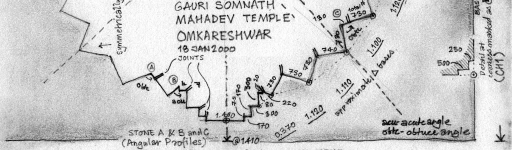
Measured drawings, also called “as is drawings”, serve an invaluable purpose of recording heritage structures for evaluating and quantifying things related to the structures. Measured drawings record to scale all parts of a structure. Scaled comparative drawings surpass any other method including photography in a methodical documentation project for any scale of a heritage structure or site.
We undertake measured drawings, including topological and GPS maps of heritage structures and sites.
The drawings are done by our team of architects, measured drawn at site and final drawings created to desired scale. We have years of experience of measured drawing of temples, temple complexes, stepwells, cave structures, palaces, residential buildings, old city streets, ruined structures and archaeological excavations – ranging over two decades.
Measured Drawing Heritage Structures
Our measured drawing experience spans over two decades since 1992 with the first academic measured drawing of a village cluster in Gujarat. The years 1992-96 consisted of academic measured drawings of Kumbhalgarh palace and fort in Rajasthan, town of Anjar in Kutch in Gujarat and havelis and street plans of the old town of Bundi in Rajasthan. In 1998 we assisted Architect R J Vasavada in the measured drawing of Shri Jaggannath Temple of Puri, Orissa.
Later in 2002-03 we undertook the measured drawing of the temple complex of Shri Eklingji, near Udaipur, Rajasthan for the King of Udaipur. Since then we have been regularly doing measured drawings in Gujarat, Rajasthan and Karnataka including for Archaeological Survey of India (ASI).
See our complete list of measured drawings from this link.
Temples


Excavated Palace

Stepwells

Cave Structures

City Gates

Forts

Residential Structures and Streets

Maps
Historical sites are not just about a building or monument, but a group of locations in a spread out region. To portray the regional relationship between sites or even an entire site like a hill fort, require use of Maps. Maps contain location of features and geography.
We draw maps for historical sites after exploration using topological, land survey and more recently GPS methods.
Site data is collected and categorised into layers to create application specific maps – maps showing water systems, routes, main features or terraces of a hill fort. Maps are used in reports and as material for interpretation – site signage or museums.

Layered CAD
Layered CAD Map of Kavaledurga with separate layers and layer groups for Features (water bodies, walls, gates, artefacts), Regions and Contour data. The layers are selectively utilised for the use and application of the map.

Similar method is used for temple drawings segregating parts of temple architecture. Using layers and groups the same CAD drawing is utilised for various application and uses. The following drawing is a part of a study of a temple complex in Siddhpur, Gujarat. The grid of drawings are based on the same drawing using different visibility of layers for each cell.

Learn more about our CAD Layer methods and application, from this post…