


Heritage Photography
Heritage and Archaeological Photography is purpose driven. Photographs themselves become things to be archived, since they capture a real moment in time. Photography is the most direct means of documentation. Considering this purpose, Photography for Heritage and Archaeology requires certain technical considerations (archival film storage, megapixel specifications, colour calibration) apart from methods and guidelines to follow in the field. All photography is in a sense documentation, yet we classify our photographs into three primary-goal driven categories:
Picturesque | Special Situation | Documentation
Our evolved standard for Archaeological surveys (excavations) and Architectural documentation (structures) makes it possible to gather photographs in similar sets for each structure or site, making it possible to compare and study different places or the same place documented in different years. We follow our own standard guidelines created especially for Indian heritage structures.
We undertake professional Photographic Documentation of Indian Archaeological and Heritage structures and sites.
We also undertake accurate artefacts documentation, incorporating true scale (sculptures or structural artefacts) and true colour values (paintings, murals) of artefacts using specialised and dedicated hardware, documentation and recording methods.
Picturesques
Photography purely for aesthetic appeal, attempting to capture and convey an experience or spirit of a place (genius loci) or a thing is Picturesque. Such photos are free from “documentation” considerations. They may crop or even hide portions of the main subject, in order to capture and convey the mood, feel or spirit strongly. It is up to the sensibility of the photographer to succeed in conveying a rich experience by the medium of photography. Archaeology has a great need for it. Picturesque photos help in propagating awareness – attracting people’s attention, inspiring them and make anyone immediately appreciate the value of archaeology.
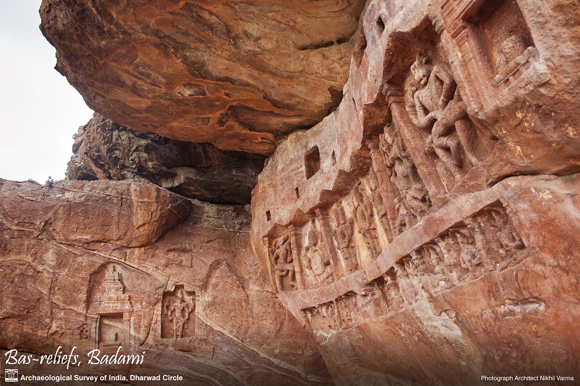
Sites in Haveri and Badami Dharwad
A set of “picturesque” images of select sites under the Archaeological Survey of India (ASI), Dharwad circle, created for their website and downloadable content.


Eklingji, Rajashthan
Set of images of several sites in the religious landscape of Eklingji taken during the measured drawing project of Shri Eklingji Temple Complex, Eklingji, Rajasthan

Special Situation
Many situations make it difficult to photograph a location. A street too narrow to capture façade elevations, a fine detail too high or too deep to access, a place deep in the jungle, a ruin overgrown with thick vegetation, a temple submerged in slush, a deep cave with little or no illumination – there can be many such difficult and dangerous situations to photograph. To photograph these requires planning, safety preparedness, right equipment and field methods to succeed in capturing valuable photographs – both for documentation as well as picturesque photography.
Deep Jungle Locations
Site of Kavaledurga hill fort in Tirthahalli remains inaccessible during monsoons due to leeches and snakes and heavy rain. There are several architectural ruins concealed in its jungle worthy of exploration, apart from the main gates, fort walls, bastions and the restored palace ruins near the top of the hill.

Inaccessible Remote Locations
Chandragutti hill fort is one of the remote places in Karnataka requiring a decent climb through forest area. Some ruined temples can’t be reached without help of a local guide. The top has more structures.

Difficult-reach situations
Some sites pose several challenges in photographing them , be it due to thick undergrowth, an overgrown tree, danger in reaching spots or places to properly view or photograph them.

Documenting geographical conditions
Documenting geographical conditions is as important as documenting the structure itself, especially in the case of ancient Indian architecture where buildings have always been designed sensitively integrating the features of the landscape. Capturing and conveying varied geographical features sometimes require a collage. These then become useful to plan conservation work.

Before-After
Comparative photos to evaluate current status of a heritage structure or to present the change after a conservation work, is continuously needed in archaeological reports. One needs to dig out old photos from archives or published material to evaluate current status, while one needs regular visits to the site and choosing fixed photo-spots for taking comparative photos to study and compare change.

Photographic Documentation of Heritage
Heritage Documentation Photography needs to follow consistent guidelines and pre-decided format for all sites – irrespective of scale or size of structure. The format and guidelines together dictate “what” and “how” to photograph. Guidelines provide how to respond to special situations or typical constraints that arise from one site to another apart from covering the technical aspects involved.
We have developed and evolved our own guidelines over years of experience with heritage sites, including naming conventions and sequence of photographing – to be consistent and organised with our photographic material right from the field. Our methodical and consistent approach helps reduce the effort of identification and organisation of hundreds of photos from a site.
ASI Documentation Reports
There are several reports done during 2007-2008 for Archaeological Survey of India (ASI), Bangalore Circle for sites in Hassan, Shimoga and Chikmagaloor. These reports were primarily photographic documentation, but combined status reporting to highlight problem areas as found during documentation.
Sites in Hassan

Sites in Shimoga

ICHR Project documenting sites after the Gujarat Earthquake
An Indian Council of Historical Research (ICHR) funded project to create a Status Report for select sites affected by the earthquake of 2001 in Gujarat. The sites were under State Archaeology or unprotected. The report covered over 35 sites in Kutch and Saurashtra, Gujarat.