

Technology for Heritage
We follow trends in technology and evaluate for use in Heritage documentation and conservation. We continuously upgrade our hardware and software to enhance the quality and precision of our work.
At core, technology does not change the traditional approach, but it does add newer and more workflows towards better precision, organisation and reliability of data. In the field while collecting data, organizing data and working in the Studio, all follow a streamline process. We have our own evolved conventions and guidelines bringing greater value to our work. Below we list out the “technology for Heritage” we use.
True Colours | Colour Management Workflow
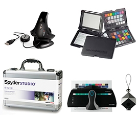 Our Studio deploys complete colour managed workflow, from capture (Camera) to view (Monitors) to Print (local and remote printers). Colour calibrated monitors and printers, including remote printers, ensures the colors in photos and graphics have hi fidelity. The Yellow we see and envision, will remain the same yellow in any of our work-product, not shift towards an orange!
This is especially critical when color hues of objects (murals, paintings, sculpture, rocks) can differ in documentation due to lighting conditions. Color Calibration technology helps in removing such color shifts by use of specialised equipment. We use professional products from X-rite and Datacolor.
GPS Collected field data | Routes, Boundaries and Locations
 We capture actual GPS data from filed, including routes and coordinates. This data is invaluable in positioning structures and artefacts accurately in maps. Scattered artefacts from archaeological and historical sites should be mapped accurately before moving them from their in-situ locations to a museum. This data will be invaluable in analytical and conjectural studies. From our first use of Nokia N95 to later N97-mini, the N8, we continue to use Nokia phones with Sports-tracker Application to gather, analyse and upload data from each of our field trips.
Panoramic Photography | Accurate 360
 With digital camera offering in camera landscape/panorama photos it may seem an everyday thing. But true panoramic photography without parallax errors (smoothened by in camera software) requires special techniques and equipment. We use specialised Tripod panoramic head and software to create accurate panoramas and 360-QTVR files, with true parallax free photographs in stunning detail.
HDR | High Dynamic Range
 Any photograph has highlights and shadows, and the in-betweens (midtones). When highlight portions capture detail properly, the shadows become too dark for detail. When Shadows are captured properly, the highlights simply white-out with no detail. Special techniques with multiple exposures help in capturing detail in both highlights and shadows properly – generally covered under HDR technology. Capturing details in all areas of sculptural artefacts, as well as cave structures with low light conditions, becomes imperative and so much possible to do with current technological advances.
Slide Archives in HRD and SRD | Infrared removal of dust and scratch defects
 Old slides and negatives form invaluable data of a previous documentation. Years ago documentation done using slides and negatives records status of sites, monuments and artefacts then. Digitising them today requires dedicated hi-res capture devices (not just hi-res flatbed scanners) with a channel for infrared to remove scratch and dust defects. We use SilverFast8 with 7200dpi optical scanner with infrared channel to achieve hi-quality, hi-resolution scans for restoration and digitisation of old negatives and slides.
3D Physics Simulation
 One of the outstanding use of 3d modelling technology is true-physics simulation. This goes beyond walkthrough, conjectural modelling and rendered images. It is possible to animate structural falls, earth movements and canon ball damages to reverse engineer and estimate causes of ruined and damaged structures. Use of computer simulation is to investigate and better understand real field data, to test hypotheses and compare models which help in archaeological interpretation(s). In 3D simulation, all of the available data can be brought together interactively as a historical reconstruction or as an invaluable operative tool for research. In a virtual environment it is feasible to scientifically simulate phenomena that otherwise would be difficult to observe or simulate in the real world, for example, lighting, computational fluid dynamics or physical forces simulation. Learn more about application of 3D in Archaeology…
Layered CAD | Not just digitised drawings
So called “AutoCAD” drawings, or more rightly CAD drawings, serve limited purpose if not done in a layered manner. Traditionally, Plan and Sections are drawn with varying line thickness determined by the scale of the drawing. In CAD, drawing remain without scale (rather 1:1 scale!) until they are printed. In CAD these lines stay without scale (or 1:1 scale) with default thickness. Freely scaling and printing a CAD drawing with default thicknesses with all drawing information is an insensitive and inappropriate use of CAD). We draw CAD drawings using our own proprietary Layering convention developed for heritage structures, combined with a block hierarchy system. We use licensed ProgeCAD in our Studio. Learn more about our CAD application in Heritage…